Snowshoe Lakes hike
Trail report by Bob Hosea
September 7, 2010
Bob Hosea recently took a hike to Snowshoe Lakes in the Cabinet Mountains.
Bob welcomes comments and questions from people about area hikes. He can be reached by e-mail at: hiking@thebobfactor.com
Here is Bob�s Snowshoe Lakes hike trail report:
==============================================
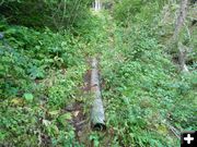
Trail #125 to Snowshoe Lakes in the Cabinet Mountains is also known as the "Snowshoe Pipeline Trail". To get to the trailhead drive 7 miles east of Libby on Highway #2 and turn right onto the Bear Creek road #278. Drive about 3 miles and then turn right onto the Cherry Creek road #867 and then drive 4 more miles and turn right onto road #6213. Drive a few miles to the end of this road to the trailhead.
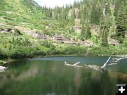
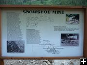
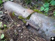
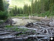
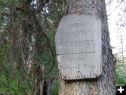
The trailhead starts near the head of Snowshoe creek where the old Snowshoe mine was once located. The Forest Service has removed all of the old buildings and has also removed much of the waste rock and tailings along Snowshoe creek and also the surrounding area. The trail to the lakes follows the old pipeline that brought water down from the lower lake to the mill site. Parts of the old pipeline still remain along the trail. The beginning of the trail is not marked at all, but the sign that is located in the parking area will give you directions on how to get to it from there.
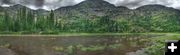
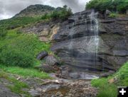
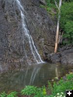
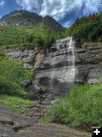
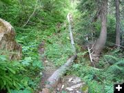
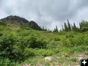
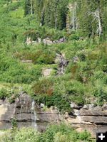
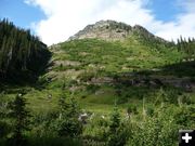
There are three very small lakes that make up Snowshoe lakes. The trail to the lakes is somewhat steep and rough in some areas and the trail will only take you to the second lake. The third lake is approximately 600 feet in elevation above the second lake. To get to the upper lake you will need to bushwhack your way up the hill. There are many moose and deer trails that you can use to help get you through the brush and up the hill. If you stay near the small creek that is coming from the upper lake you will get to see many of the waterfalls created as it comes down the steep hill.
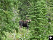
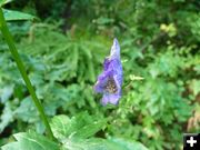
During my hike I saw one bull moose near the upper lake and one mule deer. I also saw a black bear near the parking area as I was driving in. The trail and hillside is covered in wildflowers that include Indian paintbrushes and Monkshood and many others. I didn't have any problems with biting bugs at all during my hike, and I saw a total of four other people on the trail. The entire hike was just a little over 3 miles round trip, with an elevation gain of approximately 1100 feet to the upper lake.
Click on this link for a video of this hike: http://www.youtube.com/watch?v=AbCMFLvaCOo&feature=related
==============================================
Related Links:
Snowshoe Lakes Photos by Maggie Craig, August 28, 1010 (32 pictures)
Snowshoe Mine history
Geiger lakes, Carney Peak and Lost Buck Pass hike - Bob Hosea, August 23, 2010 (30 photos)
Hike to Northwest Peak Lookout � Bob Hosea, July 28, 2010 (36 photos)
Little Spar Lake hike - Bob Hosea, July 16, 2010 (30 photos)
Granite Lake hike - Bob Hosea, June 27, 2010 (37 photos)
Bramlet Lake hike - Bob Hosea, June 16, 2010 (22 photos)
Cedar Lakes hike - Bob Hosea, June 9, 2010 (25 photos)
Rock Lake hike - Bob Hosea, May 17, 2010 (18 pictures)
Lower Geiger Lake hike - Bob Hosea, May 9, 2010 (14 pictures)
Leigh Lake hike - Bob Hosea, April 28, 2010 (7 photos)
Rock and Leigh Lake Trek � Bob Hosea, August 31, 2009 (11 pictures)
The Bob Factor - Bob's website
|