
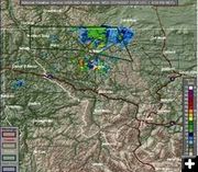
Radar at 9:58 PM for NW Montana. NWS graphic shows flood warning area and severe storm areas for Northwest Montana. The storm has moved east away from the Troy-Libby-Yaak area.
|
|
Severe Thunderstorm Warning
Strong winds, hail, heavy rain hit NW Montana
July 18, 2007
11:30 PM Update: Doppler radar continues to show a line of severe thunderstorms capable of producing destructive winds in excess of 70 mph along a line extending 9 miles NE of Fortine to 10 miles North of Libby, moving at 30 mph. Sever thunderstorms expected around Yaak, Eureka and Rexford around midnight. A Severe Thunderstorm Watch remains in effect for Northwest Montana until 1:00 AM, issued by the National Weather Service out of Missoula.
10:00 PM Update: The Severe Thunderstorm Warning issued by the National Weather Service out of Missoula for Western Lincoln County has expired.
9:38 PM Update: The Severe Thunderstorm warning remains in effect until 10:00 PM MDT for Western Lincoln County. Doppler radar continued to indicate a line of severe thunderstorms capable of producing nickel size hail and destructive winds in excess of 80 mph. These storms were located along a line extending from 10 miles NW of Yaak to Fortine and were moving North at 30 mph. This storm will be in the vicinity of Eureka by 9:40 pm MDT.
The National Weather Service in Missoula has issued a Flash Flood Warning for Columbia Falls, Eureka, Troy, West Glacier, Whitefish in Lincoln County in Northwest Montana and Flathead County until 12:30 AM MDT. Doppler Radar and weather spotters indicated flash flooding over the warned area. Up to 4 inches of rain has fallen in Libby in a 30 minute period. Kalispell has also received substantial rainfall as well. A Flash Flood Warning means that flooding, mud & debris flows are imminent or occurring. If you are in the Warning Area, move to higher ground immediately. Residents living along streams and creeks should take immediate precautions to protect life and property.
___________________________________________
8:30 PM Update: The National Weather Service in Missoula has issued a severe thunderstorm warning for Western Lincoln County in Northwest Montana until 9:15 PM MDT.
At 8:25 pm MDT Doppler radar indicated a line of severe thunderstorms capable of producing nickel size hail and damaging winds in excess of 70 mph. These storms were located along a line extending from troy to 6 miles so of Libby, or along a line extending from 19 miles West of Libby to 6 miles South of Libby and moving North at 30 mph.
Severe thunderstorms will be near Libby around 8:35 pm MDT. Power was reportedly out in Libby.
Severe thunderstorms produce damaging winds & hail along with frequent lightning & heavy rain. The NWS advises the public to go indoors and stay away from windows. If you are caught outside, move to a well protected area.
Related Links:
National Weather Service, www.weather.gov
|