
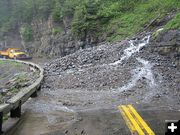
Glacier Rock Slide
Heavy rain and hail from a thunderstorm last week created a rock slide below the Weeping Wall to a depth of 10 feet. Photo by Treff Alexander, NPS.
|
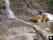
Glacier Slide
Heavy rain and hail from a thunderstorm last week created a rock slide below the Weeping Wall to a depth of 10 feet. Photo by Treff Alexander, NPS.
|
|
Flooding road & campground closures at Glacier Park
2.54 inches of rain fell in a 24-hour period
June 18, 2006
(West Glacier) Officials at Glacier National Park report that recent rain has caused flooding in parts of the park, resulting in road, campground, and trail closures.
Bowman and Kintla Lake campgrounds were closed on Friday and campers were evacuated due to flooding concerns at Bowman Creek Bridge; the roads to Bowman and Kintla Lake have been closed.
The Inside North Fork Road has been closed from the Logging Creek Ranger Station to Camas Creek due to flooding at Anaconda Creek. The Quarter Circle Bridge is also closed.
Additionally, the hiking trail to Avalanche Lake has been closed since Thursday. Several trails in the Many Glacier area have standing water, and closures may become necessary.
Visitors should use caution when crossing all park streams.
The 24-hour rainfall total at 8 am Friday for West Glacier was 2.54 inches and 1.7 inches in the North Fork.
Since the park’s road crew has been working on issues associated with the flooding, no significant progress has been made on the rock and mud slides on the Going-to-the-Sun Road which resulted from Tuesday evening’s storm. At this point, crews are unaware of any damage to the road’s integrity. Some shoulder areas have been impacted and damage was reported to the rock wall near the "Slopes." Significant debris piles remain in Logan Creek, Logan Pit, Lower Haystack, Weeping Wall, Big Bend, Triple Arches, and the area between Grizzly and Road Camp.
Visitors can continue to access Logan Pass from the park’s east side, traveling 18.5 miles from St. Mary. The Logan Pass Visitor Center is open from 9:30 am to 4:30 pm.
On the west side, visitors can travel 15.5 miles from West Glacier to Avalanche on the Going-to-the-Sun Road. The hiker/biker closure is at Logan Creek.
Visitors are encouraged to monitor current road conditions, available on the park’s web site at:
http://www.nps.gov/applications/glac/roadstatus/roadstatus.cfm. Conditions are also available by calling 511, the Montana Department of Transportation Traveler Information System. If your phone does not support 511, call 1-800-226-7623. Both numbers are toll-free. Select "Glacier Park Tourist Information" from the main menu to hear Glacier’s road report.
Photographs of the conditions are available at:
http://www.nps.gov/glac/gallery/recent06.htm.
For general information on the Sun Road and Glacier National Park, visit the park’s web site at www.nps.gov/glac or call 406-888-7800.
|