| | HOME | AREA ATTRACTIONS | OUTDOORS | EVENTS | COMMUNITY | PHOTO GALLERY | BUSINESSES | |
| | HOME | AREA ATTRACTIONS | OUTDOORS | EVENTS | COMMUNITY | PHOTO GALLERY | BUSINESSES | |
The 2.2
million acre Kootenai National Forest is located in the extreme northwest
corner of Montana, bordered on the north by Canada and on the west by Idaho.
Of the total acres, 50,384 are in the State of Idaho. The
Kootenai has been, and will continue to be, Montana's premier timber-producing
forest. Ranges of high, craggy peaks mark
the Forest with Snowshoe Peak in the Cabinet Mountains Wilderness at 8,738
feet, the highest point. The Whitefish Range, Purcell Mountains, Bitterroot
Range, Salish Mountains, and Cabinet Mountains are all part of the rugged
terrain radiating from the river valleys. In the north-central part of
the Forest, the land is more open with gently rolling timbered hills lying
in the shadows of the Whitefish Range. Access into the Forest is available
from U.S. Highways 2 and 93, and Montana State Highways 37, 56, 200, and
508. 
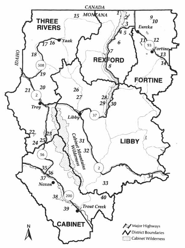
Recreationists will find many miles of backcountry roads available to access the Forest. Some areas are closed to motorized vehicles in order to protect wildlife and watershed values, offering recreational opportunities for hiking or horseback riding. Many developed campgrounds are located throughout the Forest, as well as unlimited dispersed camping areas available. Mountain bikers will find many miles of trails to enjoy with spectacular views. The winter snows typically melt in April and May, although some high country areas aren't accessible until June. Wildflowers are at their peak May-July. In August & September, berries ripen and many people enjoy picking huckleberries as a family activity. Fall brings the turning of the larch to a golden yellow and the sounds of elk bugling, marking the beginning of hunting season for deer, elk, moose, bear and other big game species. Those seeking a novel way to enjoy the Forest may enjoy reserving a fire lookout with commanding views of the surrounding terrain. (more information about Lookout Rentals) The Forest is dominated by two major rivers: the Kootenai and Clark Fork, along with several smaller rivers and their tributaries. Two dams on the Clark Fork have created the Cabinet Gorge and Noxon Reservoirs within the Forest boundary. Highway 200 parallels these reservoirs as it crosses the Forest. The Kootenai River is bridled by Libby Dam, creating Lake Koocanusa, a 90-mile-long reservoir reaching into Canada. Lake Koocanusa, 16 miles north of Libby, is almost totally encompassed by Forest land with Highway 37 following the east shore to Rexford, and a Forest road along the west shore to within a few miles of Canada. The elevation of the Kootenai River as it leaves the Forest and the State is 1,862 feet, the lowest point in Montana. The Yaak, Fisher, Tobacco, Bull, and Vermillion Rivers are smaller rivers within the confines of the Forest. There are 141 lakes located within the Forest boundaries that range from small alpine lakes to 1,240-acre Bull Lake. Hikers will find stands of alpine larch on Northwest Peak in the 19,000-acre Northwest Peaks Scenic Area, while grand old firs line the Fisher Mountain-Tepee Lake Trail. The gnarled whitebark pine greets walkers in the beautiful 15,700-acre Ten Lakes Scenic Area. And finally, for a taste of one of the grandest trees anywhere on the continent, head for the Ross Creek Cedar Grove. Wildlife that are common include deer, elk, moose and bear. The Wilderness is home to mountain lion and grizzly bear, but the chances of seeing one are very slim. Over 190 species of birds live on the Kootenai National Forest, and avid birdwatchers can pick up check-off lists at the local Forest Service District offices. Along the rivers, Bald eagles, great blue herons, kingfishers and dippers can be found. Trees native to the area include western red cedar, western hemlock, western white pine, lodgepole pine, ponderosa pine, alpine larch, western larch, mountain hemlock, grand fir, subalpine fir, whitebark pine, Douglas-fir, Englemann spruce and juniper. Cottonwood, quaking aspen, alder and paper birch grow in the moist sites and valley bottoms. Above 6,000 feet the vegetation becomes scattered, with stunted and gnarled mountain hemlock, whitebark pine and alpine larch growing out of rocky rims and ledges, many with broken tops and twisted forms attesting to the tremendous volumes of snow. Snowstorms occur as late as June and as early as September limiting most backpacking and hiking to the summer months. Plant growth is dense along streamsides at lower elevations. Common plants include huckleberry, snowberry, mountain maple, serviceberry, chokecherry, wild rose, kinnikinnick and dogwood. Wildflowers bloom throughout the summer and include lupine, arrowleaf balsamroot, beargrass, violets, trillium, columbine and Indian paintbrush. Recreational
Area Map
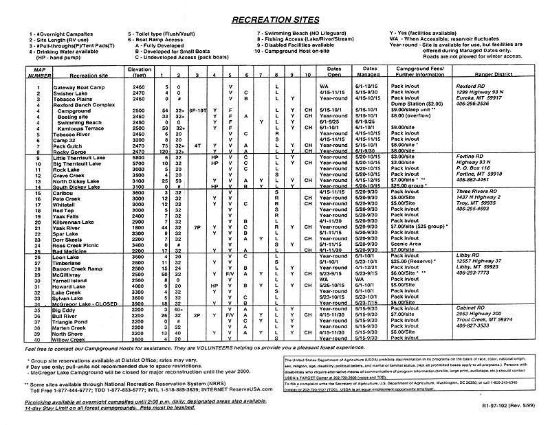
Recreational
Areas Chart
For
further information contact:
|

| | HOME | AREA ATTRACTIONS | OUTDOORS | EVENTS | COMMUNITY | PHOTO GALLERY | BUSINESSES | |