| | HOME | AREA ATTRACTIONS | OUTDOORS | EVENTS | COMMUNITY | PHOTO GALLERY | BUSINESSES | |
| | HOME | AREA ATTRACTIONS | OUTDOORS | EVENTS | COMMUNITY | PHOTO GALLERY | BUSINESSES | |
Ten Lakes Scenic Area Located in the extreme northwest corner of Montana, the Ten Lake Scenic Area of the Kootenai National Forest offers more than 89 miles of trails of remote backpacking and hiking opportunities through rugged terrain with spectacular mountain views reaching into Canada. Many high mountain lakes offer fishing for the angler and scenic views for the photographer. Mountains rise to elevations of more than 7,800 feet. High alpine mountains, cool clear high mountain lakes, peaceful meandering trails, all combine to make Ten Lakes Scenic Area a backpacker's delight. |
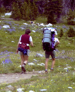
Ten Lakes Scenic Area offers remote hiking and backpacking trail experiences. |
|
 Ten
Lakes Scenic Area encompasses 15,700 acres, with an additional 19,000 acres
surrounding it. The Ten Lakes Scenic Area is one of an original nine areas
designated for special wilderness evaluation under the Montana Wilderness
Study Act. Located along the northeastern edge of the Forest with the Canadian
border as one of its boundaries, the Ten Lakes Area is dominated by a high
ridge of the Whitefish Mountains. The 1984 Montana Wilderness Study Act
recommended the Ten Lakes Scenic Area and segments of the surrounding country
as wilderness. While not officially designated, the Kootenai National Forest
is managing the area to keep its wilderness characteristics. Motorized
vehicles or equipment of any kind are not allowed in the Scenic Areas or
portions recommended for Wilderness, except for over-snow vehicles. Ten
Lakes Scenic Area encompasses 15,700 acres, with an additional 19,000 acres
surrounding it. The Ten Lakes Scenic Area is one of an original nine areas
designated for special wilderness evaluation under the Montana Wilderness
Study Act. Located along the northeastern edge of the Forest with the Canadian
border as one of its boundaries, the Ten Lakes Area is dominated by a high
ridge of the Whitefish Mountains. The 1984 Montana Wilderness Study Act
recommended the Ten Lakes Scenic Area and segments of the surrounding country
as wilderness. While not officially designated, the Kootenai National Forest
is managing the area to keep its wilderness characteristics. Motorized
vehicles or equipment of any kind are not allowed in the Scenic Areas or
portions recommended for Wilderness, except for over-snow vehicles.
Alpine glaciers shaped much of the present rugged scenery. As the glaciers grew they carved deep scallops, or cirques, and high, rim-rocked basins sheltering the many lakes of the area. The area is named for the Ten Lakes basin along the Canadian border. Other alpine lakes, often bordered on one side by subalpine vegetation and on the other by a headwall or rook harboring old snowdrifts, hide in nearly every high basin and cirque. Offering spectacular beauty are the Therriault Lakes and Bluebird Basin areas. Poorman Mountain reaching 7832 feet is the highest peak with Ksanksa, Stahl and Independence Peaks ranging from 7505 to 7416 feet scattered throughout the range. Camping, hiking and horseback riding are the favorite uses of the area, with more than 89 miles of trails available. Little and Big Therriault Campgrounds provide campsites, fire rings, water pumps and vault toilets. The Horse Camp has hitching posts, feed racks, a fire ring, table and outhouse. At Horse Camp space is provided for trailer turn-around and parking. Trailhead bulletin boards display trail maps as well as seasonal information. |
The
area is habitat to many wildlife species, including black and grizzly bear.
Backpackers are 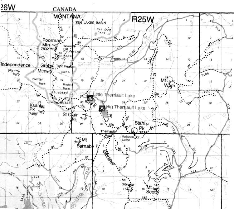 advised
to carry pepper spray and practice sanitary food storage procedures. The
area is remote, so hikers should check on current trail conditions and
advisories from the local Forest Service office before venturing into the
wilderness. The Ten Lakes is a Pack In/Pack Out area. advised
to carry pepper spray and practice sanitary food storage procedures. The
area is remote, so hikers should check on current trail conditions and
advisories from the local Forest Service office before venturing into the
wilderness. The Ten Lakes is a Pack In/Pack Out area.
Forested areas contain Englemann spruce, subalpine fir, lodgepole pine, Douglas fir, white bark pine, and the uncommon alpine larch. Wildflowers are abundant in spring and summer and a variety of forbs and shrubs, including huckleberry, grow under and around the trees. Several trails criss-cross the Ten Lakes Scenic Area and are accessed from Highway 93 via various Forest roads. Trailhead bulletin boards display trail maps as well as seasonal information. Special Hiking Considerations
|
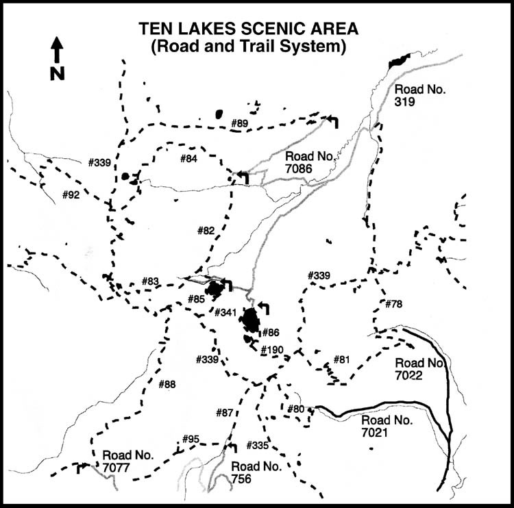
(Click on map for larger image) |
TRAIL
NO. & NAME
78 Clarence/Rich 80 Stahl Creek 81 Stahl Creek 82 Sinclair Creek 83 Bluebird 84 Wolverine Lakes 85 Little Therriault Loop 86 Big Therriault Loop 87 Terriault Pass 88 Sinclair Creek 89 Rainbow Lake 92 Blacktail 95 Therri X Country 190 Big Therr/Highline 335 Gibralter Ridge 339 Highline 341 Little Therr/Highline |
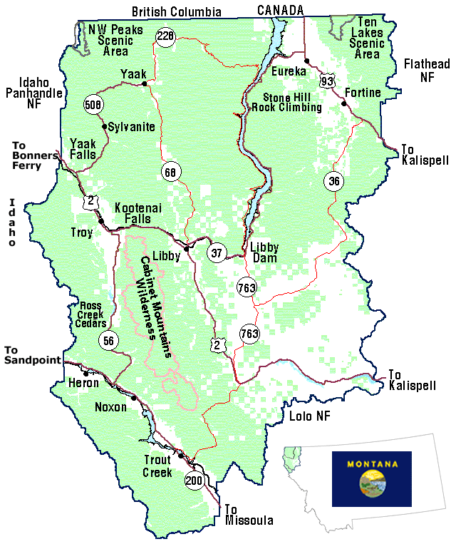
| The
Ten Lakes Scenic area is located in the northwest corner of Montana, 20
miles off Hwy 93 near Eureka and is reached by Forest Roads #114 and 319.
For more information contact: Fortine Ranger District PO Box 116 Fortine, MT 59918 (406) 882-4451 or stop by the Murphy Lake Ranger Station on Hwy 93, 2 miles south of Fortine, Montana. Information
is also available at the Kootenai National Forest Supervisor's Office:
|
| | HOME | AREA ATTRACTIONS | OUTDOORS | EVENTS | COMMUNITY | PHOTO GALLERY | BUSINESSES | |